Maptitude Geographic
Information System (GIS) software is the intelligent mapping solution for
business, government, and education. Maptitude is a powerful combination of
software and geographic data that provides everything you need to realize
the benefits of desktop mapping and spatial analysis with a single,
easy-to-use package.
Maptitude with the Europe
Country Package is the best buy for those needing to create
detailed maps and analysis in Austria and elsewhere in Europe.
Maptitude mapping software for Austria.
Locate your customers with Maptitude
Austria mapping software
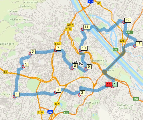
Perform drive-time analysis
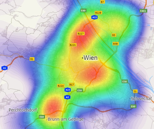
Visualise spatial patterns
Key Features of Maptitude with the Europe Country Package:
Optimises sales territories, vehicle routes, and site locations
Visualises, analyses, and presents mission-critical data
Maximises profits, time, and resources
Includes a Street layer with address ranges for geocoding (pin-mapping) and routing
Includes Postal Areas for sales and territory mapping
Includes administrative boundaries for the whole of Europe
Integrates with Google Earth for any location both inside
and outside of Europe
Supports data in many of the spreadsheet, database, and geographic formats (more...)
Includes sophisticated analysis tools for building rings (bands/buffers), facility areas of influence, hot-spots,
origin-destination flow lines, territories, drive-time rings, drive-time
territories, routes, market share, facility location, and 3D surfaces (more...)
Includes MapWizard® instant mapping technology for creating color, scaled-symbol, dot-density, and pie and bar chart thematic maps
The Edit>Preferences>System>Language>Translate Interface
option supports full interface translation into German
Includes GISDK™ application development platform (more...)
Geographic Data Included with the
Europe Country Package
The Europe Country Package for Maptitude includes extensive
geographic data so that you can get started as soon
as you install the software. The following geographic files are included: